Monthly Archives: July 2016

Semester closing Mapathon and talk by Kerstin Meyer on the use of OSM data in Togo

Dear Mapping-Enthusiasts,

before the start of the semester break, we would like to take the chance to round the semester up with a “SPECIAL” Mapping event.

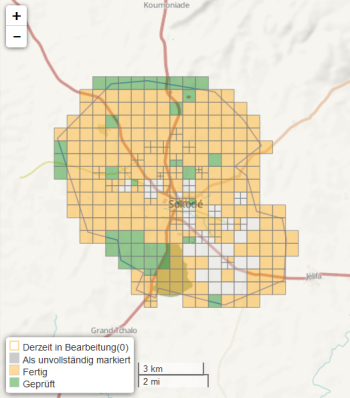
Many of you have supported the Mapping for Togo during our last Mapathon or/ and the GIS tutorial. This data was collected for the use by the local authorities in Sokode.

In this event you can learn more about the use of this data and the further OpenStreetMap activities in Togo. Kerstin Meyer of the TU Kaiserslautern will be joining us to present her work regarding the use of OpenSource Geospatial Technology in Togo with focus on OSM. She was working with the local authorities in Togo, organized mapathons and mapping trainings and was moreover out in the field to validate and add information to the data we and other mappers provided.

WHEN: Tuesday, 6 pm

WHERE: Hörsaal, Berliner Straße 48

Kerstin will open up the event with a presentation, then we will have the rest of the evening to discuss, map and to also test the new MapSwipe App- an app we developed in cooperation with MissingMaps and which is now available in the Play and App Store! For more information also see: http://mapswipe.org/

We are looking forward to seeing you all on tuesday,

the disastermappers

P.S. Please bring your own laptop and mouse (for the mapping) and a smartphone and tablet (for MapSwipe) if available 🙂


Mapping Sokodé-Report of our latest mapathon

Beginning of June students of the “Citizens as sensors” seminar organized a Mapping event to support local authorities in Sokodé. Please find their short feedback below:

Am 08. Juni 2016 war es wieder soweit! Im Rahmen des „Citizens as Sensors“ Seminar in Kooperation mit Missing Maps und den lokalen Behörden in Sokodé sowie der TU Kaiserslautern wurde eine Mapping Aktion am Geographischen Institut der Universität Heidelberg für die Region Sokodé gestartet.

Sokodé ist die zweitgrößte Stadt in Togo und umfasst ca. 120.000 Einwohner. Auch Sokodé ist vom sogenannten „urban sprawl“ betroffen, worunter hinsichtlich der erhöhten Urbanisierungsrate eine ungeregelte Ausbreitung des Stadtgebietes zu beobachten ist. Das Ziel beim Mapping Event lag vor allem darin, digitales Kartenmaterial mit freiwilligen Teilnehmern/innen für die Raum- und Stadtplanung in Sokodé zur Verfügung zu stellen.

IMG_0494

Als Einführung wurde die Region in Togo vorgestellt, sowie eine Anleitung zum Digitalisieren in OpenStreetMap mit dem externen JOSM Editor gegeben. Mit JOSM wurden im Rahmen des Events Ausschnitte aus der Region heruntergeladen, bearbeitet, erweitert und wieder in die Datenbank hochgeladen. Der Schwerpunkt beim Digitalisieren lag vor allem auf Straßen und Gebäuden.

mapping

Um die Koordinierung beim Digitalisieren zu erleichtern, wurde die HOT Tasking Manager Applikation verwendet. Hierbei wird ein Gitternetz über das betroffene Gebiet gelegt, sodass ein Bearbeiter aus dem Gitternetz eine Kachel auswählt, sie vollständig bearbeitet und anschließend als markiert erledigt.

Als Ergebnis wurden ca. 80 % des Gebietes in Sokodé als „erledigt“ markiert. So konnten die Teilnehmer/innen an dem Abend in einer gemütlichen Atmosphäre zwischen 18.00 und 23.00 Uhr einen Beitrag dazu leisten, dass digitales Kartenmaterial für Sokodé bald von jedermann verwendet werden kann!

mapping2


With one swipe and tap you put a family on the map

We are happy to announce the launch of Map Swipe – an app that allows you to support humanitarian aid by simply using your mobile.

In a disaster or humanitarian crisis, knowledge regarding the location of possibly affected and vulnerable people is crucial to provide effective support. MapSwipe allows you to map these locations using your smartphone.

Following up on the “Heidelberg Process” developed by the disastermappers heidelberg/ GIScience Research Group in collaboration with the MissingMaps team, the app enables collecting information regarding the location of residential areas using satellite imagery and a microtasking approach. The disastermappers heidelberg/ GIScience Research Group are supporting the MissingMaps project with Mapathons and by conducting research on the use of OpenStreetMap data for humanitarian aid. The app is a result of this collaboration which provides an example on how research, practice and humanitarian aid can be combined to develop more efficient workflows
(also see:
http://idl.iscram.org/files/benjaminherfort/2016/1378_BenjaminHerfort_etal2016.pdf).

Contributors are asked to mark map tiles and to thereby provide information regarding inhabited regions. One tap hereby signifies that residential features could be identified, a second tap indicates the likeliness of features. A third tap flags tiles with bad image  quality. If no features are visible you can just swipe to the next tile and go on with the task.
640px-DSC_0355

The app allows you to contribute online as well as offline, using satellite imagery that can be downloaded beforehand. Therefore the app allows you to contribute from home just as easy as on the commute.
The provided information can be utilized by mappers to furthermore digitize building structures, roads and other individual features. That way base maps that support the work of MSF, the Red Cross and other organizations are developed in a collaborative workflow.

Interested in becoming active yourself?  Learn more about MapSwipe and get the app and swipe and tap away!

MapSwipe is as of now available in the Play and App Store!

Within the first three days more than 1000 people helped to classify an area bigger than Germany! Great Job!

Offenes Disastermappers Treffen: Donnerstag 17 Uhr, Café Botanik

Hallo liebe Freunde des Disastermappings,

in den letzten Monaten war wieder viel los. Wir haben gemappt für Ecuador, in Togo und an anderen Orten. Es gibt neue Tools wie die Mapswipe App und das Missing Maps Project wird immer dynamischer.

All diese Themen gilt es wieder einmal zu ordnen. Auch hat uns eine Menge Feedback zu den vergangenen Veranstaltungen und Seminaren / Vorlesungen erreicht. Dies möchten wir zum Anlass nehmen wieder etwas “offener” zu werden.

Daher laden wir alle herzlich zum offenen Disastermappers Treffen ein. Gemeinsam in einer gemütlichen Runde (vielleicht auch bei einem Bier) möchten wir daher über neue Entwicklungen und Möglichkeiten sich einzubringen diskutieren. Gleichzeitig kann das auch eine gute Geleghenheit sein, einfach mal einen ersten Eindruck vom disastermapping an sich zu bekommen.

Wann: Donnerstag, 17 Uhr
Wo: Café Botanik – Melli hat ein Missing Maps Shirt an! 😉
Wer: Alle am Thema Disastermapping, Humanitäre Hilfe, Katastrophenmanagement interessierte mit oder ohne Vorkenntnisse

Liebe Grüße und bis Donnerstag,
eure disastermappers