Many things will be different this year when celebrating Christmas, but we think that the few people that you are going to meet should still get a nice OSM-based presents. This is why we want to invite you to join our annual “Christmas Workshop” and learn how to create nice posters, post cards and other things with maps.
As last years (we started this in 2017!) we will present different ways to craft personal Christmas gifts based on OpenStreetMap features. We will show you how!
Liebe disastermappers-Freund*innen und Vorkämpfer*innen für freie Geoinformationen!
Es ist wieder so weit: Unsere Veranstaltungsreihe“Open Data und die Sustainable Development Goals” geht in die zweite Runde!
Nachdem wir uns im Sommersemester schon dem Thema Nachhaltige Entwicklung und deren Verknüpfung mit der Relevanz von frei verfügbaren Geodaten gewidmet haben, legen wir in den kommenden Veranstaltungen den Fokus auf den Zugang zu Trinkwasser und Gesundheitsinfrastruktur. Ihr könnt euch dabei auf spannende Veranstaltungen, zusammen mit Akteuren aus der Praxis wie Viva con Agua (VcA), dem Deutschen Roten Kreuz, CartONG und OSM Ghana freuen.
Unser Auftakt-Mapathon “Kartieren für das Menschenrecht auf Wasser- mit Viva con Agua” findet am Di., 17. November um 16.00 Uhr wie gewohnt online statt. Tretet dafür einfach unter folgendem Link dem Online-Mapathon bei:
Nach einem Einblick in die Arbeit von Viva con Agua in Uganda werden wir gemeinsam fehlende Kartendaten für Gebiete erheben, in denen sich VcA für das Menschenrecht auf Wasser einsetzt.
Bis jetzt sindweltweit nicht überall gleichermaßen freie Kartendaten verfügbar, was oftmals Möglichkeiten für Katastrophenschutz, und -vorsorge, Bedarfsanalysen für Hilfsorganisation und viele weitere Zwecke einschränkt. Seid daher dabei und werdet Teil der weltweiten OSM-Mapping-Community! Jede*r ist willkommen – egal, ob ihr bereits erfahrene Mapper oder Neulinge seid! Ein vorbereitetes Tutorial sorgt für den passenden inhaltlichen Einstieg für Anfänger*innen, sodass keinerlei Vorkenntnisse benötigt werden.
Was ihr benötigt:
Bereitet am besten ein Headset vor um euch austauschen zu können, sowie eine Maus, welche das Kartieren erleichtern wird. Leider können wir euch zur Zeit nicht mit Snacks und Getränken versorgen – daher denkt daran, euch etwas vorzubereiten; dann macht die Veranstaltung noch mehr Spaß!
Wir freuen uns auf euch und stehen bei Fragen natürlich immer gerne zur Verfügung.
Den kompletten Veranstaltungsplan für dieses Semester findet ihr am Ende des Artikels!
let’s close this semester with a relaxed mapping session next Tuesday, 28-07, from 6pm on. This time we are just going to pick some projects from HOT’s Tasking Manager and chat while we’re mapping. Join us and become part of the global mapping community via https://heiconf.uni-heidelberg.de/loh-py6-jxt. Please prepare a headset to communicate, as well as a mouse, which will make mapping more comfortable. If you haven’t mapped before: No problem. Everyone is welcome and our mapping tutorial ensures an appropriate introduction to all contents.
Initially we planned to finished our series “Open Data & the Sustainable Development Goals” with a workshop on Mapping Poverty. However, unfortunately we did not manage to set up the workshop properly in time (shame on Benni and Nathan who started with high aspirations but too late with the preparation of the workshop ;)). Our idea was to do something along the lines of the following workflow described in this paper in Science Magazine: Combining satellite imagery and machine learning to predict poverty. For everyone interested in the field, we might find some time during our mapping session to discuss how we can make this workshop happen in the future.
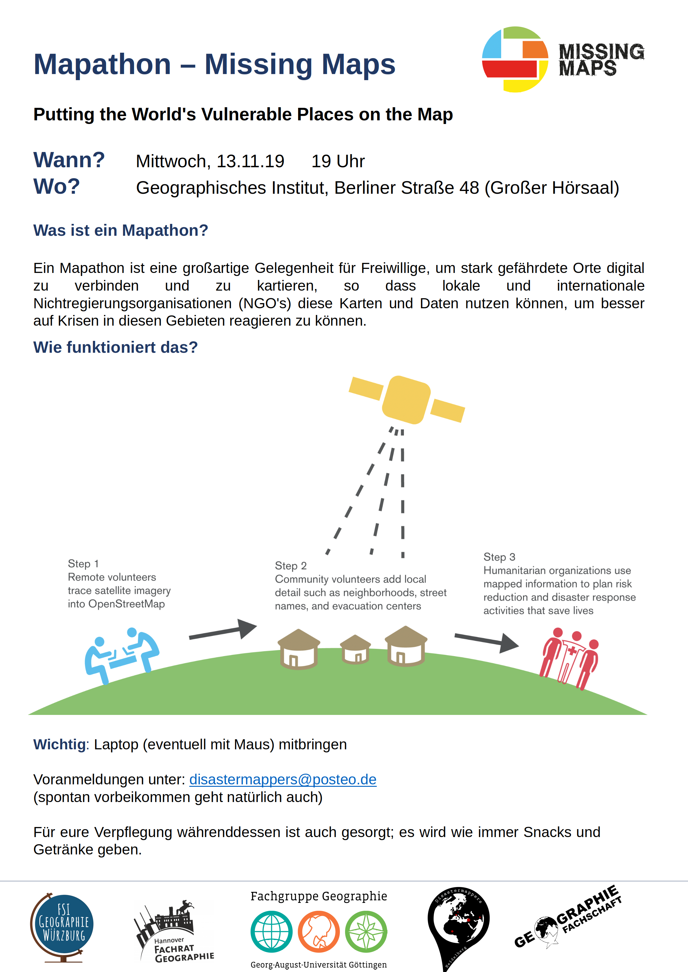
im Rahmen der Geography Awareness Week laden die Geographie-Fachschaften der Standorte Göttingen, Hannover, Würzburg und Heidelberg und die disastermappers heidelberg herzlich zum standortübergreifenden Mapathon ein!
An diesem Mapathon werden wir gemeinschaftlich mit Hilfe von OpenStreetMap und fernerkundlichen Methoden neue Kartendaten für vernachlässigte Krisenregionen erstellen und somit humanitäre Hilfsorganisationen in ihrer Arbeit unterstützen. Welches Gebiet genau kartiert wird, wird spontan entschieden, schließlich soll aktuelle Hilfestellung geleistet werden.
Erstmalig wird die Veranstaltung an vier Standorten gleichzeitig stattfinden, mit einem gemeinsamen Programm eröffnet und sich dabei per Videokonferenz über Fortschritte und Problematiken ausgetauscht.
Seid dabei und werdet Teil der weltweiten Mapping-Community!
Jede*r ist willkommen und ein vorbereitetes Tutorial sorgt für den passenden inhaltlichen Einstieg. Es werden keinerlei Vorkenntnisse benötigt!
Bringt am besten einen eigenen Laptop und eine Maus mit, für alles andere ist gesorgt! Snacks und Getränke werden selbstverständlich zur Verfügung gestellt.
Mit freundlichen Grüßen im Namen der Fachschaften Geographie Göttingen, Hannover, Heidelberg und Würzburg, sowie den disastermappers heidelberg
This year the bi-annual German Congress for Geography was held in Kiel in northern Germany. The conference is the main platform for German speaking researchers to exchange recent research results in the field of geography. Besides this, a growing number of events are being organized by students and “young” geographers as part of the “Youth Congress for Geography” (JKG). HeiGIT and the disastermappers Heidelberg contributed to JKG by organizing a mapathon on friday.
The mapathon was supported by the student associations from Heidelberg, Hannover and Göttingen and was attended by around 40 students. We introduced them into OpenStreetMap mapping, the use of HOT’s Tasking Manager and MapSwipe. Besides this, the event was a good occasion to build connections between students from all over Germany. We envision to grow the mapping community by having more regular events. Geography awareness week will be held in November. So stay tuned for updates and events coming soon.
Christmas is just around the corner and we are organizing another workshop on the use of OpenStreetMap data. As last year we will present different ways to craft personal Christmas gifts based on OpenStreetMap features.
Additionally we will also show how to use open satellite imagery archives captured by Sentinel and Landsat mission. Together we will create posters, postcards, calendars or everything you need to imprint a T-shirt. We will show you how!
When: 13.12.2018, 4 pm Where: Small PC-Pool + SR, Berliner Straße 48, Heidelberg
Snacks & drinks on us. 🙂
No prior knowledge needed. Please bring your own laptop + mouse.
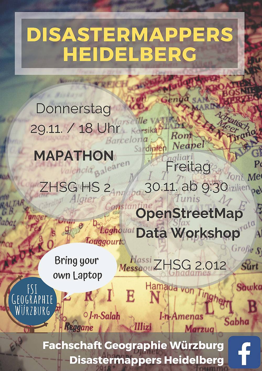
In the last week a delegation of disatermappers heidelberg and Fachschaft Geographie Heidelberg took the train towards Würzburg for a two days OpenStreetMap event organized by the local student association FSI Geographie Würzburg.
On thursday we organized a mapathon contributing to two Missing Maps projects requested by Doctors Without Borders (MSF). The first project is located in Embu County, Kenya and MSF is supporting health centres there to develop a model of care for Non Communicable Diseases such as diabetes or epilepsy. The second project dealt with the Ebola outbreak in the Democratic Republic of the Congo. During our mapathon we introduced more than 60 students into how to map streets, buildings and forests in OpenStreetMap.
The second day was dedicated to OpenStreetMap data as well. However, this time we focused on data export and visualization rather than data creation. In a three hours workshop we presented several ways to download OpenStreetMap data and directly tested it together with the students. You can have a look at the slides in the tutorial section of this blog.
We are really thankful for the invitation by the FSI Geographie Würzburg and are looking forward to support the growth of local OSM community. It was a fantastic stay.
This weekend Heidelberg was the host city of this semesters geography “BuFaTa” (Bundesfachschaftentagung). During this four day event student associations from Germany, Austria and Switzerland and their members came together to discuss, learn and spend time together. The event was organized by an excellent student team from Heidelberg.
We as disastermappers Heidelberg contributed to the BuFaTa by organising a Missing Maps mapathon as one of the plenty working group activities. During three hours we presented an overview on mapping activities to support disaster management and humanitarian aid. Furthermore, the participants became active themselves by contributing data to MapSwipe and/or OpenStreetMap. By spreading the word about the work of the Humanitarian OpenStreetMap Team, Doctors Without Borders and the Red Cross organisations and our local team at the Heidelberg Institute for Geoinformation Technology, we hope to help to establish more mapathons in other German cities organized by local student groups.
A group of motivated students during the mapathon (Foto: Daniel Wagner)
Everyone insterested in organising mapathons at his/her home town is welcome to contact us. We’re happy to share our experiences we gained on the long journey we started already in 2013 during the mapping efforts after Typhoon Haiyan. Just write an email to disastermappers@posteo.de or contact us via Twitter or Facebook.
For the ones, who can’t wait to learn more: We already have a list of tutorials and workshop material available under the tutorials section of this blog.
Again, thank you for the great attendance and let’s stay in contact! We can’t wait to pack our things and come to your universities! 🙂
Mapping Settlements using the MapSwipe app (Foto: Daniel Wagner)
Many people asked us, whether it would be possible to see their own contributions to MapSwipe on the map. Therefore, in the last few days we worked on a small project to extend our MapSwipe Analytics page.
The new “Live View” shows the latest contributions from the MapSwipe volunteers and functions similar to the show-me-the-way tool, which shows the latest edits in the OpenStreetMap database. The new tool can be used during mapathon to foster the motivation of the volunteers, but also to discuss the individual results. Or just let it run and have a look at the great efforts of the MapSwipe volunteers.
This work is generously supported through core funding from the Klaus Tschira Foundation Heidelberg for establishing HeiGIT.


 A group of motivated students during the mapathon (Foto: Daniel Wagner)
 Mapping Settlements using the MapSwipe app (Foto: Daniel Wagner)
